Directions
History
Way to Sinharaja Forest Reserve
- The forest steeped in deep legend and mystery. The word Sinharaja means, lion (sinha) king (raja) and the popular belief is that the legendary origin of the Sinhala people in Sri Lanka is from the descendants of the union the lion king who once lived in the forest and a princess. Sinharaja Forest Reserve is one of the least disturbed and biologically unique lowland rain forests now remaining in Sri Lanka.
- This forest covers an extent of approximately 11187 ha. From east to west the length of the forest is about 21 km. And its width from north to south is about 3.7 km. The Sinharaja forest was initially declared a Man and Biosphere Reserve (MAB) in 1978, as representative of Tropical Humid Evergreen Forest ecosystem in Sri Lanka and has been recognized by UNESCO as part of its International Network of Biosphere Reserves.
- Subsequently it was declared a National Wilderness Area, under the National Heritage Wilderness Area Act, in 1988 and lately a World Heritage Site in 1989.It is the Sri Lanka 's first natural resource to earn this esteemed distinction. This forest is situated in the southwest lowland Wet Zone of the country at latitudes 6 21- 6 26 and longitudes 80 21- 80-34.It spans over the administrative districts of Ratnapura, Galle and Matara.
- Sinharaja forest consists of a series of continuous ridges, aligned approximately in an east-west direction and lies between the tributaries of the Kalu Ganga in the north and the Gin Ganga in thesouth.There are four main routes of access to Sinharaja.
- The Kalawana- Weddagala road from the northwest, The Rakwana-Morning side estate road from the northeast, the Hiniduma-Neluwa road from the southwest and Deniyaya-Pallegama road from the southeast. Among these roads the Kalawana-Weddagala road is shorter and more convenient for visitors traveling from Colombo.
Way to Sinharaja Forest Reserve
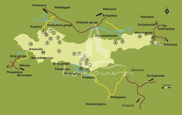
Sinharaja involves 3 districts. They are Galle, Matara and Rathnapura. Boundaries of Sinharaja rain forest is as follows.
The access paths to enter forest reserve
Location
6º 21ºº N - 6º 26ºº N
80º 21ºº N - 80º 34ºº N
- Southwest - Low and wet zone, Sabaragamuwa and southern province
- North - Nspolagamuwa, Koskulana Ganga
- South - South West - Gin Ganga
- West - Kalukanduwawa Ganga
- East - Barley Tea Estate
The access paths to enter forest reserve
- Kudawa entrance - Colombo --> Kalawana --> Kudawa
- Pitadeniya Entrance - Galle or Matara --> Deniyaya --> Pitadeniya
- Morning Side Entrance -- Galle or Matara --> Deniyaya --> Morning Side Estate
Location
6º 21ºº N - 6º 26ºº N
80º 21ºº N - 80º 34ºº N
Locations
Geology and soil structure
- The Forest Reserve lies within the transition zone of two important groups of rock types, the south/western group which consist of metasediments-charnokites and scapolites bering calc granulites and the highland group comprising khondalites of metamorphosed sediments and Charnockites.
- The most significant geological feature of Sinharaja is the presence of a "Sinharaja Basic Zone" which comprises hornblend pyriclasts, basic charnokites pyroxene amphibolites and scapolite.
- The soils of Sinharaja largely belong to the group of Red Yellow Podzolic soils, with clearly distinguishable horizons of varying soil depths.
- The soil is well drained with very little accumulation of organic matter.
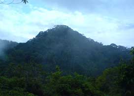
- The elevation of the Sinharaja reserve ranges from 200m to 1300m.
- It has a rolling terrain consisting of a series of ridges and valleys, which assumes an east-west trend in the northwestern part of the reserve.
- In other parts of the reserve, the ridges and valleys assume a north-west/south-east alignment.
- The peak of Hinipitigala is the tallest, rising up to about 1150m.
- Other important ridges in the reserve ranges between 550-800m in height NamelyMoulawella (760m), Kosgulana (797m), Sinharaja (742m), Kohilearambe (575m), Dotalugala (769m), and Tibbottagala (904m).
- Upto now, the Sinharaja Reserve covers an area of 8,800 hectares of nature and modified forests.
- The Reserve lies in the south-west of the island at 6021' - 60 26' N. and 800 21' - 800 34' E.
- It measures 21 kilometers in length, and if 7 kilometers in width at its widest point and 3 kilometers at its narrowest.
- It consists of approximately 6,091 hectares (15,054 acres) of Forest Reserves and 2,773 hectares (6,850 acres) of Proposed Reserves. Peaks of Sinharaja
- Pinipitigala main complex – 1171 MSL
- Pinipitigala west – 1170 MSL
- Pinipitigala east – 1168 MSL
- Mulawella – 760 MSL
- Pathinigala – 605 MSL
- Sinhagala – 742 MSL
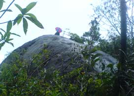
- In Sinharaja rain forest there are several places to visit in Kudawa side. Mulawella is a peak of Sinharaja forest and it's 6.5 km far from main entrence. Sinhagala is center of Sinharaja forest and 14 km from entrance.
- The grant Nawada tree (Sharea stipularis) which is endemic species type of Sri Lanka and grant tree at 6.0km from main entrance.
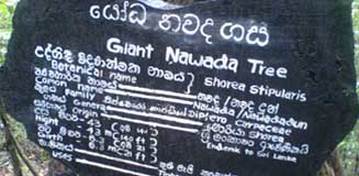
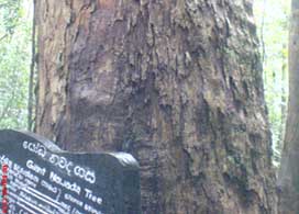
- Grant Nawada tree (Sharea stipularis) which is endemic species type of Sri Lanka and grant tree at 6.0km from main entrance. Number of Nature trails we can identified on travel to visit Grant Nawada tree.
